
Map of Wichita County, Kansas showing the location of the Cemeteries
Please note-the picture below is a
thumbnail. Click on it to view the full size map however the file size
is quite large and it will take a few minutes to load. Use your browsers
back button to return to this page.
An effort has been made to compile records on all known cemeteries
and single graves that are known
to exist in Wichita County. We have a database on computers in the research
room with names of people buried in the following cemeteries.
Lydia Lutheran (Evangelical) Cemetery (also know as Zion Lydia Lutheran)
Lydia Lutheran (German) Cemetery
Another burial was made by the lone tree near the northeast corner of the southeast quarter of section 13-17-38. This grave is about five and one-half miles west and six and one-half miles north of the intersection of Leoti, Kansas.
Courtesy of ‘History of Wichita County Kansas – Volume 1’. Compiled
by John K. Glanville.
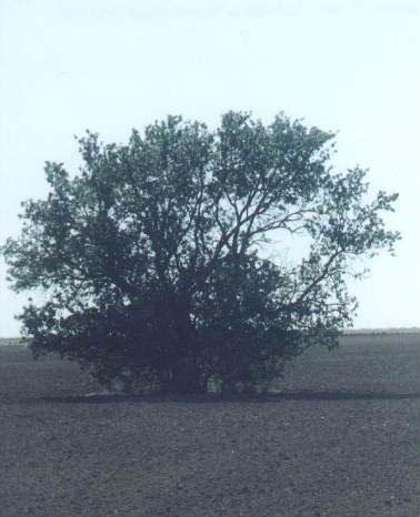 A Gorsuch is buried here.
Click on the picture for a larger view-use your browsers
back button to return to this page
There is also a grave in the Willis pasture about 60 rods east and 30 rods south of the northwest corner of the northwest quarter of section 8-19-36. It is about four miles south and one and one-half miles east of the intersection of Highway 96 and Highway 25 in Leoti, KS
Courtesy of ‘History Of Wichita County Kansas – Volume 1’. Compiled by John K. Glanville.
Thomas County Historical Society tours Wichita County cemeteries--click here for related story